Awarded Bachelor and Master Theses 2017
Lost Rivers in Lodz
Author: Klaudia Jaskula
Course of studies: International Master of Landscape Architecture (Masterthesis)
Supervision: Prof. Uta Stock-Gruber, Prof. Ingrid Schegk (Weihenstephan-Triesdorf University of Applied Sciences)
Abstract
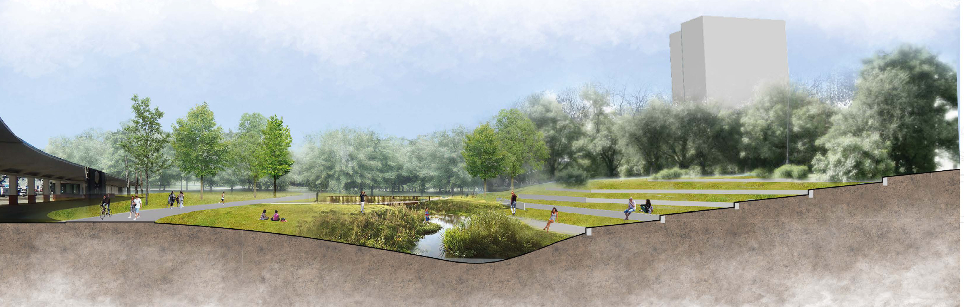
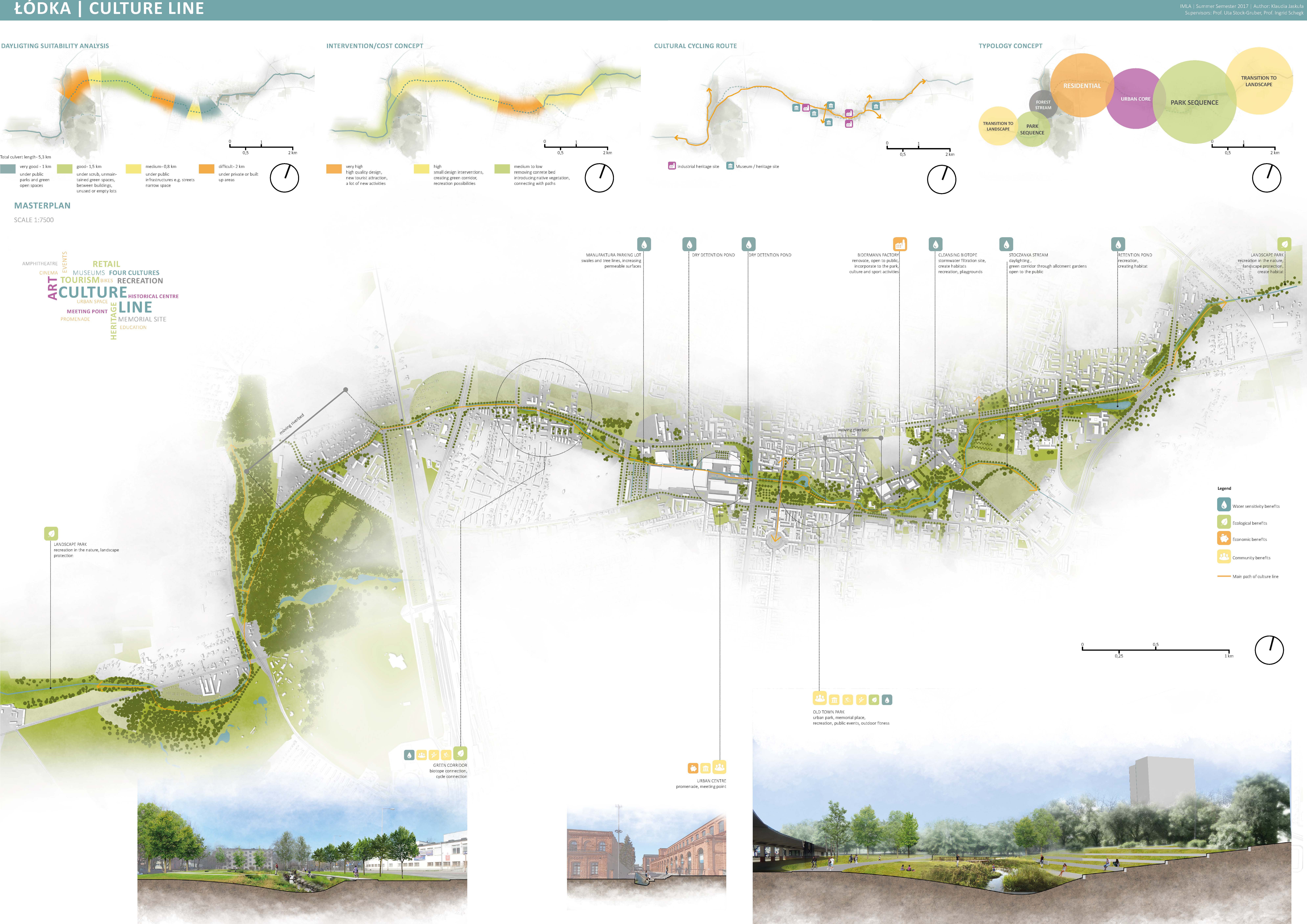
The work deals with river and stream systems in Lodz, which currently run mainly in underground channels through the city and which in the future should be openly guided to structure and cool the city.
The planning work is based on a broad research in theory and practice.
After viewing and evaluating international examples (such as Seoul, Singapore, Zurich) and the research project "Integrated Urban Water Management", the potentials for Lodz with regard to the uncovering of rivers and streams were analytically sounded out. By means of a very focused analysis of the city of Lodz, the student developed two strong new open space axes across the city at the framework planning level, which respond to different localizations in a typologically logical way.
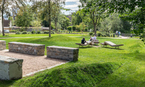
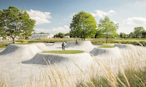
In the following, on the one hand a creek running along the cultural heritage of the industrial age in Lodz was worked through in terms of design, on the other hand a creek creating a varied cultural mile along museums and innovatively used industrial monuments.
Justification for the award
The proposed concepts meet the challenges of climate change in a very natural way by means of generously dimensioned retention areas and cooling water axes. Likewise, the two east-west oriented river spaces are at the same time high-quality connecting spaces for alternative mobility approaches, beyond the public street spaces.
The created "green-blue" infrastructures of the city can at the same time counteract the problems of social change, which arise from migration, as many new attractive "addresses" and qualities of stay are created in the city, which are effective for working, living and recreation.
Growing Interventions - Strategic Development and Hazard Mitigation Concept for the Informal Settlement Onaville, Haitig
Author: Ines Hoffmann
Course of studies: Chair of Landscape Architecture and Public Space (Master-Thesis)
Supervision: Prof. Regine Keller (TU Munich)
Summary
Onaville is part of the emerging informal settlement "Canaan" 15 kilometers north of Port-au-Prince. It is located on an alluvial cone south of an eroded mountain range. This thesis proposes a strategy for urbanization and hazard mitigation in the context of the rapid urbanization of this informal settlement.
By means of green infrastructure, a network of open spaces is implemented to be of public use and assist in flood mitigation.
The concept of "Growing Interventions" is based on the idea of implementing punctual interventions at selected locations that spread out and consequently influence the whole settlement. It fosters the existing social and economic structures by providing the required infrastructure and support to impel necessary and beneficiary transformations. The punctual interventions are neighborhood centers, at Ravine Madaniel combined with bridges. In and by these centers, the concept of green infrastructure is promoted.
Those comparatively small interventions become an interconnected system and result in a major improvement of the resident's livelihoods.
The bridges enable safe crossing of the ravine in daily life as well as in disaster situations. The neighborhood centers serve as market hubs and meeting points. They provide services such as public toilets, showers, laundry facilities, storage rooms for market goods and street lighting combined with facilities for cellphone-charging. The system of green infrastructure is promoted in workshops. Plants are prepared to be planted for green infrastructure measures in nurseries.
Justification for the award
Ms. Hofmann has developed a master plan approach in Port au Prince, Haiti, which builds on existing research approaches at the chair and her own field work. While in the informal settlement of Canaan, Haiti following the massive earthquake in 2010, she developed a landscape-based participatory cultivation project on a large flood channel.
Her intensive engagement with the climatic, hydrological and vegetation conditions on site and the constructive dialogue with the inhabitants, makes this very good work so remarkable.
Domberg Freising XXL "down above" - Urbs Pons Mons
Author: Susanne Kurfer
Course of studies: Chair of Landscape Architecture and Public Space (Bachelor-Thesis)
Supervision: Prof. Regine Keller (TU Munich)
Summary
The design URBS PONS MONS creates a high-quality and urban, but still green place to stay at the waterfront for citizens and tourists in the center of the historic city of Freising. In addition, the design aims to provide an ecologically sound, yet aesthetically pleasing enhancement of the areas south of the Domberg and to improve the connectivity of paths for pedestrians and cyclists in this area.
This is achieved by transforming the Moosach bank into a natural swimming pool and by carving out valuable amenity areas, as well as by connecting the south bank with the north bank by means of a bridge. On the one hand, this creates a path to the train station, and on the other hand, it ensures an east-west connection via the Fürstendamm. In order to reach the Domberg directly from the south, a lift will be installed in the south, from which one can reach the roof of the underground car park on the Domberg via a footbridge.
The natural swimming pool has integrated seating steps at the water's edge and a sunbathing lawn. The inlet of the water area is equipped with stones, which increase the river dynamics and provide habitat for various plant and animal species, and with perennials for flowing water.In this area, the water depth is shallow, allowing visitors to wade to the island with mature trees located in the water. The island provides recreational and recreational space, as does the adjacent wooden platform that floats close to the water. The integration of a café in the existing Renovabis building increases the quality of stay at the waterfront and enlivens the place, as does the youth hostel, which has found a place in the former Brey mill.
The existing children's play area on the southern bank of the Moosach will be expanded into a larger playground with water play equipment and will offer additional space to linger. The Raingardens around the parking lot of the supermarket area south of the Moosach will filter the surface runoff and retain rainwater during heavy rain events. In addition, they add ecological and aesthetic value to the heavily sealed parking lot and guide visitors coming from the train station via the new connection across the Moosach to the Domberg.
The design of the herbaceous areas on the northern bank is based on a tall herbaceous vegetation, as can be observed in nature in damp locations and along streams. They line the paths and inspire the observer with their structural diversity and colourfulness.
Justification for the award
In her thesis, Ms Kurfer has very convincingly succeeded in developing a proposal for the development of a carefully thought-out leisure landscape on the banks of the Moosach at the foot of the southern Domberg in Freising. In addition to a sensitively integrated river pool, she has planned long overdue pathways and recreational spaces. Furthermore, with her idea of "Raingardens", she propagates an interesting, microclimatically and ecologically effective space in the urbanised area.
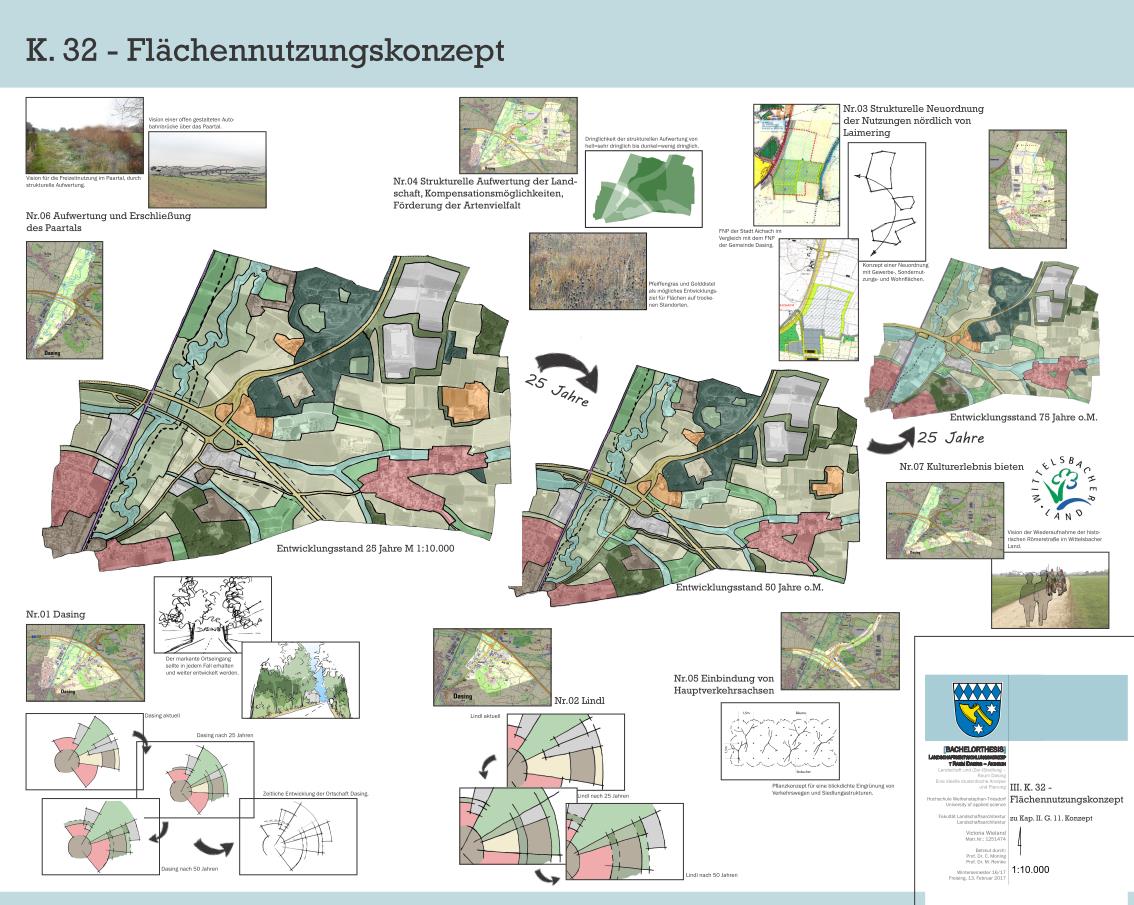
Landscape development concept for the Dasing-Aichach area
Author: Victoria Wieland
Course of studies: Landscape architecture, focus on landscape planning (Bachelor thesis)
Supervision: Prof. Dr. Christoph Moning (University of Applied Sciences Weihenstephan-Triesdorf)
Summary
The bachelor thesis deals with the problem of increasing land use in Bavaria. On the basis of an example the theoretical approach of the reorganization of a sprawling area by landscape planning and urban planning analysis is presented. The objects of protection according to §1 BauGB and the current urban development situation are dealt with. The area under investigation is located in the Augsburg region at the very well connected junction of the motorway A 8 and the federal road B 300. In addition to the analysis, the regionally active local action group of the LEADER region "Wittelsbacher Land" is presented for this particular area.
The discussed deficits, conflicts and potentials are summarized in a concept and treated by different solution approaches. In addition, the temporal development of land use is presented in a framework of 75 years.
Due to the very specific conditions in the area under investigation, caused by topography, protected areas, etc., large parts of the concept can only be adopted for areas with similar features. More generally formulated measures, such as the structural upgrading of the landscape, can be applied in any landscape area.
The consequences of land use are in part irreversible or can only be reversed over long periods of time. The use of new land, particularly through the designation of building land, should therefore be well considered.
Justification for the award
The work is based on a well-founded analysis of protected goods. It offers good approaches for sustainable settlement development in the area studied. Ms. Wieland succeeds in designing development perspectives for the next decades for this complex existing situation, which both follow a sustainable vision and appear realistic at the same time. Remarkable are the flexibly presented development perspectives, which have been developed in a good design style. Ms. Wieland succeeds in skillfully integrating the learned contents of landscape planning and urban planning into a future-oriented concept.
- Latitude: 0
- Longitude: 0